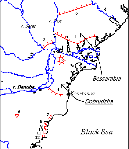
Map of the earthen fortifications from the second half of VII-th and the beginning of the VIII-th c.
The Bulgars of Asparukh occupied the easternmost part of Great Bulgaria, which disintegrated after the death of Asparukh's father khan Kubrat. Asparukh had for eastern neighbours the Khazars and thus his Bulgars were the first to face the Khazar onslaught in mid-VII-th c. Unable to resist, they had to retreat to the west.
The Byzantine chroniclers Theophanes and Nicephorus provide evidence for the settling of Asparukh in the Lower Danubian lands:
'At last the third of them (the brothers), called Asparukh, after crossing Dnepr and Dnestr rivers which are to the north of Danube, and after capturing the Oglos (Onglos), settled in the lands between it and the aforementioned rivers, because he noticed that that place was protected and difficult to attack from any side; being swampy in the front and from the other sides - surrounded by a ring of rivers, it offered great security against enemies for the weakened by the parting people.' [1].Almost identical is the information of the patriarch Nicephorus [2]. According to him the place of refuge was called Onglos (Oglos) [3]. The story of the subsequent battle of Asparukh against the Byzantine emperor Constantine IV provide more info about the location of the Onglos:
'And the emperor Constantine, learning that a ungodly and filthy people settled in the lands beyond the Danube, in the Oglos, and that they attack and devastate the lands near the Danube, i.e. the presently held by them country, previously held by the Christians, was very upset and ordered for the departure of all troops to Thrace. And after arming the fleet, he set against them by land and by sea with the intention to make war with them and to chase them out. The infantry moved in battle lines towards the so called Oglos and the Danube and the fleet was ordered to anchor nearby. The Bulgars, seeing the dense and numerous lines, became desperate, fled in the aforementioned fortification and prepared themselves for defence. In the next 3-4 days nobody of them dared to show up and the Romans did not seek a battle because of the swamps. The filthy people, seeing the Roman weakness, recovered themselves and became bolder. The emperor suffered from a fit of gout and had to return to Messembria to take baths, leaving his generals to start the fighting and to engage them in a battle if they leave their fortifications. Otherwise, to put them under siege and to check their advances. The cavalry, however, spread the rumour that the emperor was deserting them, and fled on their own, without being chased by anybody. The Bulgars, seeing this, attacked and chased them and killed most of them by swords, and many were wounded. And after chasing them up to the Danube, they crossed it.'Particularly important in the above passage is that the Onglos was a system of fortifications, which the Byzantines could not overcome despite their numerical superiority. This information significantly facilitates the localization of Onglos, which otherwise could be placed anywhere - in the south, in the north from the Danube delta or even in Wallahia.
Map of the earthen fortifications from the second half
of VII-th and the beginning of the VIII-th c.
The archaeological investigation revealed that the earliest type of
Proto-Bulgarian defences in the Lower Danube region (the second half of
the VII-th c. - VIII-th c.) were the earthen ramparts and ditches. The
earliest ones, undoubtedly built before the year of 680 (the year of the
Constantine debacle) are the Southern Bessarabian rampart and the Galac
fortified camp. The total length of the north-facing Southern Bessarabian
rampart is 126 km, its mean width - 31 - 41 m. Its western end is 35 km,
and its eastern end - 28 km from the Danube. Immediately next to its western
end is situated the fortified camp at Galac, which encompasses the land
between the rivers Seret and Prut and is surrounded by water from three
sides. The more vulnerable NW side was protected by a rampart and ditch
with total length of 27 km, very similar in structure and dimensions (42-43
metres mean width) to the Southern Bessarabian rampart. Two more fortification
are situated to the south of Danube: the Little Dobrudzhan rampart and
the Nikulicel fortified camp. The Little (Southern) Dobrudzhan rampart
covers the narrowest part of Dobrudzha, between the Danube and the town
of Konstanca, and it is the oldest of the three earthen ramparts in Dobrudzha.
The other two - the Large earthen rampart and the Stone rampart are to
the north of it and face the north, while the the Little Dobrudzhan rampart
faces the south. The Nikulicel fortified camp in Northern Dobrudzha was
protected by an intricate system of earthen ramparts, it encompassed an
area of some 48 km2 and could serve as an excellent refuge for a numerous
population.
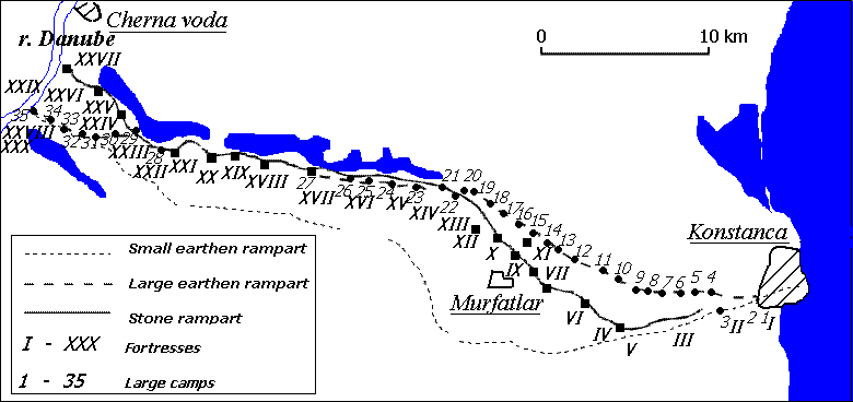
Scheme of the Dobrudzhan ramparts between Cherna voda
and Konstanca.
All these data show that an identical in structure system of defences was built on the both sides of the Danube. Both in the south and in the north there was a fortified camp and it obstructs the equivocal location of the Onglos, used as a refuge by the Bulgars of Asparukh. Most popular is its identification with that part of Southern Bessarabia, which is surrounded by the South Bessarabian rampart. Others identified the Onglos with the Galac fortified camp. K. Shkorpil [4] proposed that initially, up to the 60-s of the VII-th century, the Bulgars of Asparukh settled in Southern Bessarabia and built the Southern Bessarabian rampart for defence against the Khazars. Later, they occupied Northern Dobrudzha and built the Little Dobrudzhan rampart against the Byzantines. His opinion was further elaborated by R. Rashev [5] and this is the generally accepted reconstruction at present. According to R. Rashev the Nikulicel fortified camp was the centre of the Asparukh territory, some 15,000 km2.
The archaeological and textual evidence reveal that the led by Asparukh Bulgars, who settled on the both banks of the Danube delta, were a relatively numerous group of nomads, with a robust military organization and significant experience in the military engineering, which allowed them to built an extensive system of defences in a relatively short period of time.
[Previous]
[Next]
[Back
to Proto-Bulgar Page]
1. Theophanes Op. cit. p. 357-358.
2. Nicephorus. Op. cit., p. 34.
3. That name is found in the two forms:
Oglos (![]() ) and Onglos (
) and Onglos (![]() ).
Its etymology is still a matter of debate. Some researchers derive it from
the Slavic
).
Its etymology is still a matter of debate. Some researchers derive it from
the Slavic ![]() (pronounced "ong'l"
= angle, corner). According to them it covered the lands between the rivers
Prut, Dnestr and Danube, which were later to be called Budzhak, a Turkish
translation of 'corner'. Others think that O(n)glos comes from the Turkic
agyl
(
(pronounced "ong'l"
= angle, corner). According to them it covered the lands between the rivers
Prut, Dnestr and Danube, which were later to be called Budzhak, a Turkish
translation of 'corner'. Others think that O(n)glos comes from the Turkic
agyl
(![]() ), meaning "yard, an enclosed
place".
), meaning "yard, an enclosed
place".
4. K. Shkorpil. Starobylgarski pametnici. - V: Dobrudzha. S., 1918, s. 226 sl.
5. R. Rashev. Zemlenata ukrepitelna sistema na Pyrvoto bylgarsko carstvo. - V: Pliska-Preslav, 2, s. 99.